
Footing the Climate Bill for the World
Sponsored by
The vast forests of the tropics are givers of life. Eighty percent of the Earth’s land animals and plants live there. And more than 250 million of the world’s poorest people make their livings from the forest.
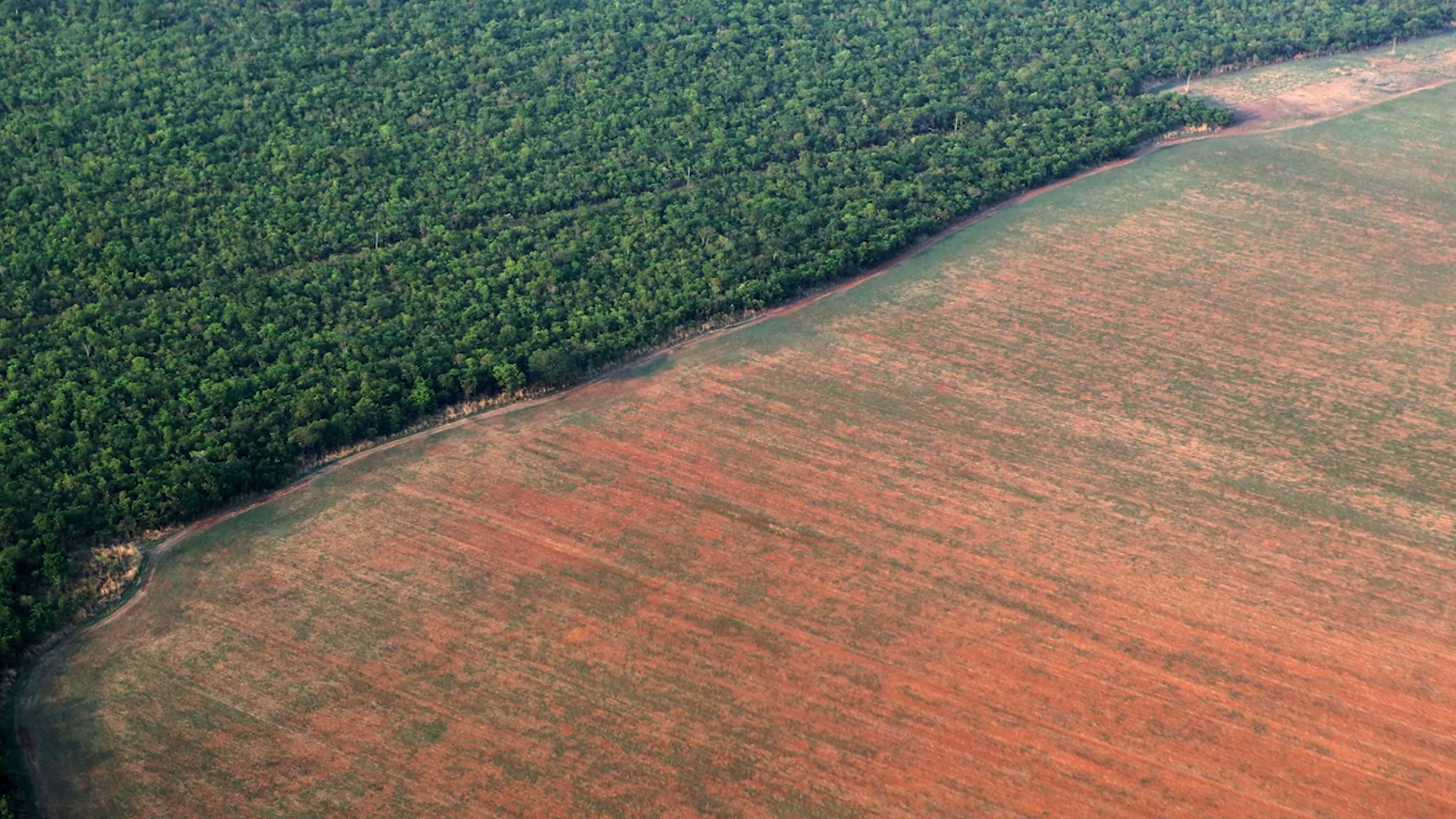
Forests matter. The trees of the Amazon produce one-fifth of the oxygen we breathe. All the world’s forests keep more than 200 billion tons of carbon out of the atmosphere. But every year, fire, bulldozers and lumber crews clear millions of hectares of forests – an area bigger than New Zealand. In just the last 40 years, the world has lost a forest area equal in size to all of Europe.
Protecting the Forests of the World
One nation, however, stands out. The government of Norway is the first to fund programs that help tropical nations rein in deforestation. A grant to Brazil in 2008 helped preserve enough forest to keep 3 billion tons of carbon out of the air. A 2010 agreement with Indonesia offered incentive payments for reducing emissions – and that nation’s carbon output dropped by half in just a few years.
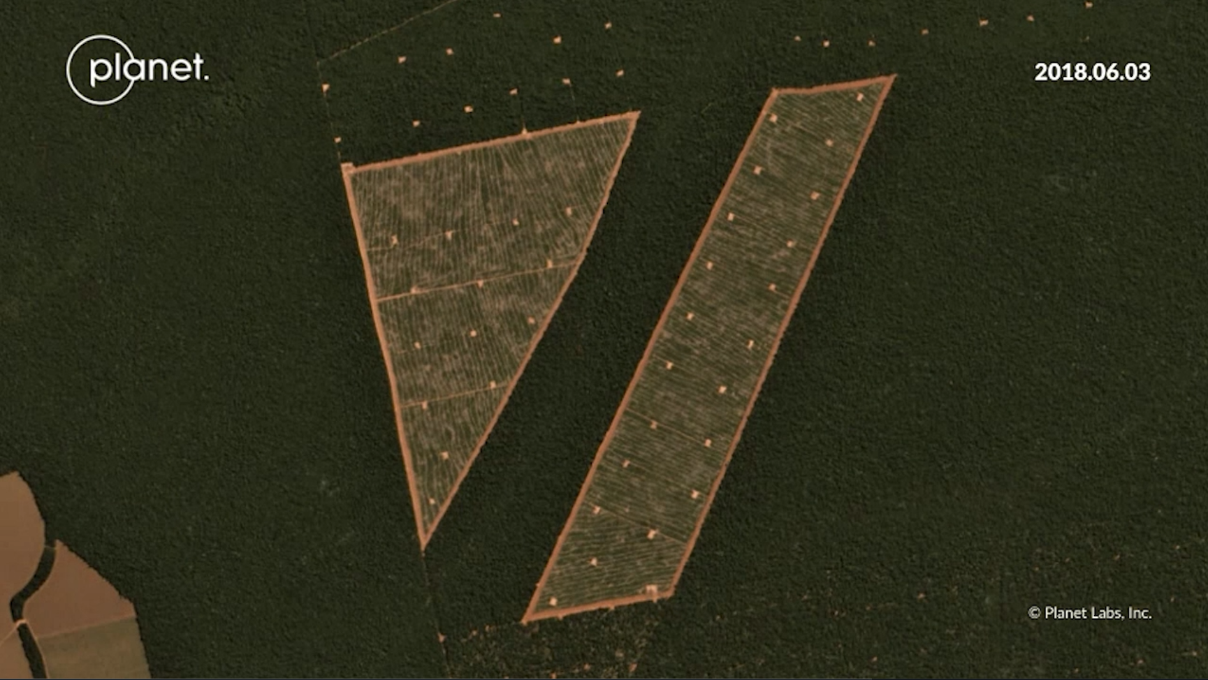
In 2020, Norway took another step. It announced a first-of-its-kind public-private partnership with Planet, Airbus and KSAT. Together, they would provide access to detailed satellite imagery covering 64 countries – all for free.
Satellite Companies Partner to Help
Planet operates a vast fleet of small satellites called Doves. They take pictures of all the Earth’s landmass every day. Those pictures are detailed enough to reveal individual trees. Airbus is adding an archive of images captured by its Spot satellites since 2002. These allow today’s forests to be compared to those from years ago. The Norwegian company KSAT is pulling together all this data and providing technical support to users, who can view and download the files from Global Forest Watch or Planet.
For the founders of Planet, this effort is the realization of a dream. When CEO Will Marshall, Chief Strategy officer Robbie Schingler and Chris Boshuizen left NASA to found the company, their goal was to provide actionable data on the whole planet at the speed of change. This lets governments, businesses, and researchers make smarter, more informed decisions to better protect our world’s ecosystems.
For Norway, the images show its forest funding at work. As the country’s former Minister of Climate and Environment told the BBC, “We decided to foot the bill for the world.”
So, the next time you take a deep breath, thank Norway – and the images and technology that come from companies like Planet, Airbus and KSAT. Together, they are helping keep the life-giving forests of the world alive.

Planet's Doves, which make up the world’s largest constellation of Earth-imaging satellites, “line scan” the planet to image the entire Earth daily. They launch new satellites into orbit every three or four months. Planet designs and builds its satellites in-house, allowing us to iterate often and pack the latest technology into our small satellites. Complete vertical integration enables them to respond quickly to customer needs and perpetually evolve their technology.
Planet's Mission Control team uses patented automation software to manage our fleet of satellites, allowing just a handful of people to schedule imaging windows, push software in orbit, and download images to 45 ground stations throughout the world.
Planet processes and delivers imagery quickly and efficiently. They use the Google Cloud Platform and enable custom processing so that customers can to tap directly into our data, the same way we do. Planet's data pipeline ensures easy web and API access to Planet’s imagery and archive. They make every scene available as a tile service, composite scenes into mosaics, and build time-sliced mosaics so you can see change over time.